Severe storms and heavy rainfall possible this week | What you need to know
After a quiet start on Monday, an active pattern sets up for the middle part of the week. Here’s what you need to know.
LITTLE ROCK, Ark. — April has been a busy month for the Natural State, and it looks like we’ll end the month similar to how we started.
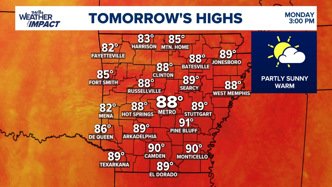
Monday will be a nice, tranquil day with highs approaching 90-degrees. A few stray showers can’t be ruled out in northwest Arkansas, but we’ll likely stay dry in central Arkansas, under partly sunny skies.
Things will start to change by Tuesday, though.

What should I expect?
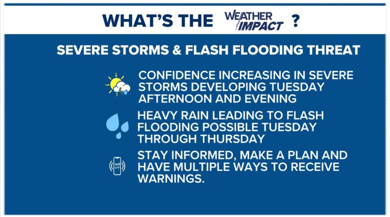
On Tuesday, a cold front will help set the stage for showers and thunderstorms developing primarily across the northern half of the state.
That front will close in on northwest Arkansas by Tuesday evening, but it will stall in southern Missouri before it actually passes though the state.
There is a level 2 out of 5, or “slight” risk of severe weather for locations north of central Arkansas and the Little Rock metro.
There will be ample storm fuel and moderate wind shear, however, there could be enough wind shear to support the development of isolated supercell thunderstorms.
Large hail and damaging wind gusts will likely be the main hazards, but an isolated tornado cannot be ruled out.
Should I be concerned about possible flooding?
The aforementioned front will stall in southern Missouri on Tuesday until Thursday, leading to heavy rainfall across portions of the state.
On Tuesday, the flood threat will be highest across northern and northwestern Arkansas, and on Wednesday, it will be highest across the western half of the state.
This front is expected to complete its passage through the state from Thursday into Friday, so scattered showers and storms will become more isolated in coverage by Friday morning.
Relatively cooler and drier air is expected to move in for the weekend, offering a quieter start to May.
It’s important to note that April 2025 is already ranked as the fifth wettest April on record in Little Rock, and the heavy rainfall on Tuesday and Wednesday could bump this ranking up.
This week’s severe risk and flooding risk.
What do I need to stay safe?
Make sure to have several ways of receiving warning notifications, including the THV11 app which can be downloaded through Google Play or the Apple App Store.
Also, it’s a great time to go over your severe weather safety plan with your family just in case a warning is issued. If warnings are issued, be sure you follow us on the THV11+ streaming app. It’s a FREE download for your television from AppleTV+, Amazon Firestick, Roku devices, or your Samsung TV.
As always, we appreciate your weather reports, pictures, and videos, but your safety is our primary concern. Don’t risk your safety by getting a photo or video.
You can text your reports or pictures to 501-376-1111 or submit them to our THV11 Weather Watchers Facebook page.