Once landslide susceptibility maps surrounding population centres are ready, monitoring the triggering mechanism would ensure that timely warnings are provided
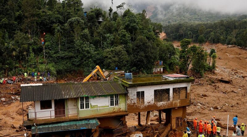
On July 30, two villages, Mundakkai and Chooralmala, in the Wayanad district of Kerala, were hit by landslides. On October 4, while noting that the disaster ranked among the deadliest in India, Chief Minister Pinarayi Vijayan said that 231 people had died and 41 remained missing. The catastrophic event has once again exposed our helplessness in the face of nature’s fury. At the same time, it has raised questions about our approach to disaster management not only in the area of Wayanad that was affected this time and that has suffered a few deadly landslides over the last four decades, but for the State as a whole.
No longer relatively disaster-free
With the sea to its west and the Western Ghats to its east, Kerala used to be considered a relatively disaster-free zone. Its development activities have taken place on this premise. Settlements are distributed throughout the State, from the coastline to the steep hill slopes. Kerala is perhaps the only State where human settlements have sprung up along the coastal line. Though the forest boundary is frozen, there are encroachments by the people and for development projects. Along with settlements, roads and other infrastructure have been built with complete disregard for natural drainage and slope stability. The average population density of the parts of the Western Ghats in Kerala is well above the all-India average.
The natural advantage of being relatively disaster-free seems to be waning. In the last few decades, the intensity and frequency of disasters have increased. Kerala has three distinct geographic zones, and all three are facing disasters, especially floods and landslides. Coastal erosion, a regular phenomenon, has affected more than 250 kilometres of the total coastal length of 590 km in the State. Besides, sea surge has affected different parts of the coast. The lowlands and midlands suffer from floods. Parts of the lowlands surrounding the Vembanad lake get inundated during every monsoon. The World Meteorological Organization described the Kerala floods of 2018 as the ‘floods of the century’ and attributed the disaster to climate change. Landslides in the Western Ghats are also becoming regular during every monsoon.
Landslide inventory map needed
Wayanad, located to the east of the Western Ghats bordering the Mysore plateau, is characterised by deep gorges and ravines. Like the river Sharavati, the Chaliyar also originates in the eastern side of the Western Ghats. Both these rivers cut across the mountain range and debouch into the Arabian Sea, in spite of the easterly tilt of the Wayanad-Mysore plateaus. This can be attributed to the existence of tectonic factors. A spatial correlation exists between tremors and landslides. Incidences of fractures/cracks have been reported from Wayanad and Idukki post landslides. Tremors were felt in parts of Wayanad after the July landslide as well. Recurring incidences of landslides and the huge human and economic losses call for scientific re-appraisal of the causative factors, which are now being simplified and confined to parameters such as slope, soil thickness, rainfall intensity and duration, and land use change. The ongoing debates show that there is a gap in understanding the incidence of landslides in this region.

Global research in this field calls for a nuanced approach. We need a landslide inventory map of each region/area. To finalise zones susceptible to landslides, we can prepare a landslide susceptibility map factoring in the geological set up (lithology, structure and tectonics, rock composition, physico-mechanical properties), slope, soil characteristics, hydrologic parameters, drainage and infiltration, vegetation cover, human activities such as mining and quarrying, slope alteration, and agricultural activities. Once such maps surrounding population centres are ready, monitoring the triggering mechanism (rainfall or tremors in the case of Kerala) would ensure that timely warnings of landslides are provided, and lives saved. The State and trained local self-help groups can do this together.
Due to rapid warming of the Arabian Sea, there is an increased risk of extreme weather and climate events, such as floods, heat waves, and cyclones. The heat content of the Indian Ocean has risen rapidly since the 2000s. There has been an anomalous increase of 1.2°C in summer sea surface temperatures over the last 100 years in the generally cool western Indian Ocean (Arabian Sea). This has created an environment conducive for cyclogenesis (development or strengthening of cyclonic circulation in the atmosphere) in the Arabian Sea. The impact of these changes is being felt on Kerala. In 2017, Cyclone Ockhi hit the State. It was the most severe cyclonic storm to affect Kerala in recent memory.
Editorial | Unnatural disaster: On the Wayanad landslides
On the whole, the ‘safe operating space’, a term coined by Johan Rockstrom and the group at the Stockholm Resilience Centre in the case of global environmental change, is shrinking in Kerala. The occurrence of staggered events of floods and landslides, and simultaneous landslides on either side of the hill ranges, as in Wayanad and Vilangad (Kozhikode district) this time, and at Puthumala (Wayanad district) and Kavalappara (Malappuram district) in 2019, also warrant elucidation.
A paradigm shift
Under these circumstances, there is a need for a paradigm shift in disaster management practices, which are mostly reactive, top-down, and revolve around rescue, relief, and rehabilitation. Globally, this has given way to a more proactive and comprehensive approach of addressing all aspects of a disaster cycle, such as preparedness, resilience, risk reduction, mitigation, reconstruction, recovery, response, and relief. The Sendai Framework for Disaster Risk Reduction provides guidelines for disaster risk reduction. It recognises the primary role of the State in disaster risk reduction but says that the State should share this responsibility with other stakeholders including local governments, the private sector, and communities. We need to understand the risk of disaster, strengthen disaster risk governance to manage the risk of disaster; invest in disaster risk reduction for resilience; and enhance disaster preparedness for effective response to ‘build back better’.
First, Kerala needs to work out disaster risk zones based on multiple criteria covering both physical and social components within a social ecological frame with the help of subject experts and generate a permanent database. As landslides and floods follow watershed boundaries, the disaster risk zones must be translated according to the watersheds/river basins. Second, Kerala needs the people’s participation in preparing disaster risk maps. Given its experience in the People’s Plan Campaign, it is important for Kerala to introduce a community-based disaster risk management in which at-risk communities are actively engaged in identifying, analysing, planning, implementing, monitoring, and evaluating disaster risk reduction initiatives. This would provide opportunities for strengthening communication, discussion, and learning within the community and between the community and the local and Central government. It would also ensure a bottom-up approach, help reduce tension and potential conflicts and pave the way to integrate disaster risk management in local level development. A quadruple helix model involving community and social organisations, academia/research institutes, the government, and business and industry may be useful.
Srikumar Chattopadhyay, Scientist (retired), Centre for Earth Science Studies, Thiruvananthapuram; K. Soman, Scientist (retired), Centre for Earth Science Studies, Thiruvananthapuram
Published – October 05, 2024 01:26 am IST