New flood models show how Mendenhall River levee should work during next glacial outburst
Flood inundation maps that model how Juneau’s Mendenhall River levee should perform have finally arrived, and there’s a lot of information to wade through.
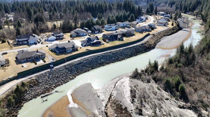
The maps show that the levee would protect Mendenhall Valley residents against a flood of the same 16-foot magnitude as last year. Deputy City Manager Robert Barr said the levee built from HESCO barriers would effectively push water into a western floodplain where nobody lives.
“At an event similarly sized and somewhat higher than what we saw last year, the HESCOs are extremely protective of property in the Valley,” he said.
Although the barriers end at Rivercourt Way, the levee is modeled to also protect downstream buildings like Safeway, the Mendenhall Valley Public Library, Thunder Mountain High School and the Alaska Club. Upstream, the maps appear to show that there’s almost no difference between having the levee or not at this flood height.
An 18-foot flood would be a different story. In terms of volume, Barr said this would be about 50% more water than the 16-foot scenario. While the maps show that water would not flow over the top of the levee, some water would seep around the end of the barriers near Diamond Park and flow through Meander Way.
In this scenario, models show that more homes and businesses both upstream and downstream would be severely flooded, including the neighborhood near the Juneau International Airport. The levee would still protect against some of that downstream damage, and could possibly increase some upstream damage. But Barr said that the barriers wouldn’t cause water to reach areas that weren’t already going to flood in their absence.
In the 18-foot scenario, some households that are not helping to pay for the levee would also benefit from it. That’s because when the city passed an ordinance creating a Local Improvement District to fund and approve the project, the highest flood modeled at that point was 16 feet.
The city’s model of a 20-foot flood only shows what would happen without the barriers. Barr said maps projecting whether the levee would work in such a catastrophic flood are forthcoming.
Barr said this would be double the water volume seen in last year’s flood. He said the model shows the absolute worst-case scenario, combining every possible thing that could happen at once.
“Think things like twice as much water in the basin, faster discharge rate, a 200-year atmospheric river event, high tide,” he said.
The likelihood of such an event is unknown because the maps simply show what might happen if Mendenhall Lake rose to a certain level. Put in a number, and the model spits out a scenario. It’s not predicting the probability of these scenarios.
Barr said that because the model is built on recent flood data, it is most likely to be accurate at predicting where the water will go in floods similar to those the community has experienced: 16 feet and below.
“The model that we have is a model, and it’s a best guess, and it’s most accurate based on what happened in the past,” he said.
Where the maps show flood heights that have never happened before, from 17 to 20 feet, they have a lower confidence rating.
The maps also only show whether areas would flood or not — they don’t show how deep the water would be on any given property. Barr said that researchers are working on an interactive website so people can mouse over the maps and see projected depths. Those maps are expected to be released later this month.
City officials will take this information to the Assembly on May 12 to discuss whether to extend the barriers further down. Residents can tune in.
City officials also encourage Mendenhall Valley residents to apply for federal flood insurance and to send their questions to floodresponse@juneau.gov.