Heavy rain and strong storms expected in Arkansas on Saturday | What to know

Rain is expected to make a return to Arkansas this weekend and some ingredients will be in place for the chance of severe storms.
LITTLE ROCK, Ark. — Rain is expected to make a return to Arkansas for the weekend and some ingredients will be in place in parts of the state for the chance of severe storms.
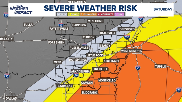
There will be warm and humid air that will build into south and southeast Arkansas on Saturday afternoon and evening.
As a result, a weather impact alert has been issued for Saturday, Feb. 14, 2025 from noon to 8 p.m. for the potential of severe weather. Here’s what to know.
What should I expect?
Any storms that develop in this part of the state will have the chance of producing damaging winds, large hail, and/or a tornado.
However, there will be a sharp cutoff on how far north the unstable air will be able to travel.
At this time it looks like the highest chance and most favored areas of strong to severe storms will be located in Cleveland, Jefferson, Arkansas, Monroe, Lee, Phillips, Drew, Desha, Calhoun, Bradley, Ashley, Chicot, Union, and Lincoln counties.
The threat of severe weather will decrease rapidly for areas in Central Arkansas.
Should I be concerned about possible flooding?
Another element of this system is the potential for minor flooding with the possibility that some areas could see several inches of rain. A flood watch has been issued for a large part of central and northeast Arkansas on Friday night through Saturday.
Heavy rain and strong storms expected in Arkansas this weekend
What time will the storms arrive?
Showers and storms will develop on Friday night into Saturday morning. Pockets of heavy rain could cause minor flooding issues for smaller creeks and streams, and low-lying and poor drainage areas.
Some of the strongest storms may produce pea-sized hail and a lot of lightning overnight into early Saturday morning.
The coverage of showers and storms will grow over the region on Saturday and storms will intensify in south and southeast Arkansas as the temperatures warm well into the 60s and 70s.
Any storms that develop between noon and 8:00 p.m. have the greatest chance of being strong to severe
The threat of all severe weather across the state will be over by 9:00 p.m. on Saturday.
Conditions on Sunday will be much colder and windy as the temperatures slide down into the 30s and 40s for highs.
During any severe weather, it’s important to remember that the THV11 Weather Impact Team has you covered.

