Experts call for more efficient methods of tracking farm fires; say current count may be an underestimation

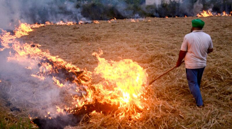
Image for representative purposes only
| Photo Credit: ANI
With air quality in Delhi plummeting to hazardous levels, despite a five-year decline in the instances of stubble burning in Punjab, experts suggest that the current approach to satellite-based tracking of farm fires by government agencies may be leading to under-reporting the number of fires.
Hiren Jethva, a researcher who studies air flow in particulate matter and the role of farm fires at the Morgan State University in the U.S., has been saying in a series of posts on X since mid-October that the drop in instances of fires from Punjab may be an illusion.

The data on fire counts are from a heat-sensing instrument on two American satellites — Suomi-NPP and NOAA-20 polar-orbiting satellites. Instruments on polar-orbiting satellites typically observe a wildfire at a given location a few times a day as they orbit the Earth, pole to pole. They pass over India from 1 p.m. to 2 p.m.
The instrument on them, called the Visible Infrared Imaging Radiometer Suite (VIIRS) can sense aerosols, smoke, heat and is considered the most accurate to track wildfires across the globe. While the satellites map any particular location twice in 24 hours, they can miss fires that are set and extinguished outside of the period of tracking. Data on fire counts reported by the Punjab government and other agencies around the world are reliant on these polar-orbiting satellites.
Mr. Jethva said that data from another satellite, the GEO-KOMSAT 2A, a Korean satellite that, unlike the polar satellites, tracked the same swathe of Earth continuously, seemed to suggest that there was a spike in smoke and fires in the late afternoon in both Punjab province in Pakistan and Punjab in India. However, he hasn’t furnished the actual fire count data from the KOMSAT.
Moreover, the quantity of aerosols, or airborne pollutants, in the atmosphere hadn’t shown any measurable change despite a decline in fire counts, he posted. “(There is a) drastic downward trend in fire detection in north-west India since 2022. However, aerosol loading in atmosphere has increased or is near stable, raises suspicion that farm fires are ignited after satellite overpass time. No blame on farmers but lack of policy implementation,” he posted on October 28.
As of November 17 this year, there have been 42,314 fires reported since September 15. This is the lowest since such data was made publicly available in 2012. In 2016, 1,33,442 fires were reported during a comparable period — an all-time high, according to bulletins by the Indian Agricultural Research Institute.
Last year 65,600 fires were recorded — about half of them from Punjab alone. The State, being India’s highest paddy cultivator, has been responsible for 50-60% of farm fires in most years. This year, however, Punjab reported only 8,404 fires as of Nov 17, or a fifth of the total. Haryana too has reported a record low of only 1,000 fires. But this has had little impact on the air quality over Delhi with a turn in meteorological conditions — the developing fog and westerly winds — accumulating massive loads of particulate matter over Delhi.
Newer parameters
Other researchers also suggest that merely relying on fire counts from the polar satellites may be inadequate and newer satellite data parameters, such as estimating the actual extent of fields burned, may be a more accurate indicator of the true measure of stubble burning.
“Since 2018, it is well-known among researchers that fire counts on their own don’t capture the entirety of stubble burning. Knowledge also has percolated to farmers to avoid burning during satellite passes,” said Nimish Singh, Associate Fellow, The Energy Resources Institute and an expert on air quality monitoring. “Next year, satellite data sets using burnt area are likely to be available. While stubble burning has certainly reduced with increasing use of the biomass in industry, I don’t believe that it is as low as being reported. Tracking methods have to be updated.”

Professor Sachidanand Tripathi of the Indian Institute of Technology, Kanpur said that eastern Pakistan has reported a massive spike in air pollution in the past 10 days and therefore would have ferried great quantities of pollutants across the border.
Ground-based pollutant monitoring networks in Lahore and Islamabad had been reporting an Aerosol Optical Depth (AOD) of 4. AOD refers to the degree of dimming of sunlight due to atmospheric particulate matter. “Delhi ranges from 1.5 to 3. Four is a very high number though I’m not sure of the exact causes. But a lot of those pollutants have been travelling towards northern India. We need much better monitoring to understand this problem better,” he said.
Published – November 18, 2024 10:35 pm IST

